Adventures (and Misadventures) of Elliott and Mary
Issue 35 - Summer 2009: The Rideau Canal
Unlike some of the other canals (the Erie and the Trent-Severn as
examples), commerce was not the primary construction objective.
The undertaking was a military operation to construct a relatively
safe line of supply from Montreal to Kingston. Safe from those hairy Americans!!
The 'Lower' Rideau Canal

|
The red squares on the charts are locks, sometimes more than one assembled
into 'flights'. The back door of one is the front door of the next one
(usually).
Since we went from South (Kingston) to North (toward Ottawa) our pictures
are primarily organized that way. What that means is that as you go DOWN
the page you are moving UP the map (North). But this is nothing new for
Canada. Ogininally there was Lower Canada and Upper Canada. The directions
were with respect to the flow of the St Lawrence River, thus, Quebec which
is north of Ontario was 'Lower' Canada and Ontario, 'Upper'
Canada..
I could say I have it backwards for this 'Lower' portion because the
current is flowing toward Kingston, but thinking about Upper being below
Lower hurts my head.
|
Click on the thumbnails for pictures
Kingston
and Kingston Mills
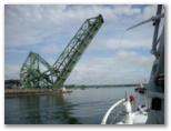 We
entered the Rideau Canal at Kingston and started up the Cataraqui River
for the flight at Kingston Mills.
We
entered the Rideau Canal at Kingston and started up the Cataraqui River
for the flight at Kingston Mills.
The Bascule bridge opens on the hour (except for the 8:00 rush hour
so you have to make a decision. We chose the 9:00 o'clock.
Kingston Mills
We (unknown to us) hit the lock at Kingston Miles just right. It is
a flight of 4 locks and apparently because of that, one of the 'choke points'
on the waterway. Since you can't have boats going up and down at the same
time, the entire flight is dedicated to one direction or another. Consider,
nominal transit time for one chamber is 1/2 hour. This puts transit time
for the 4 lock flight at about 2 hours up and slightly less coming down.(Emptying
the lock goes faster because the locktenders can allow the chamber to empty
at a higher rate than they like to fill an occupied one).
The
Brewers
 We passed by Lower Brewers (LB) on the way up but stopped on the way back.
There is power below the lock at LB and above at Upper Brewers (as the
names suggest). Just up the hill at LB is a good sized outlet store for
the local apple orchard. You can order fresh apple pie for tomorrow (they
may even have some left today).
We passed by Lower Brewers (LB) on the way up but stopped on the way back.
There is power below the lock at LB and above at Upper Brewers (as the
names suggest). Just up the hill at LB is a good sized outlet store for
the local apple orchard. You can order fresh apple pie for tomorrow (they
may even have some left today).
Jones
Falls
 The
flight at Jones Falls has 3 lock chambers and then a turning basin and
then the fourth lock. I asked about overnighting in the basin and the lock
tender said "Oh, no.... If a lock gate leaked too much or a log got caught
or vandals opened a gate you would be sitting on the bottom come morning."
I didn't pursue that idea ant more.
The
flight at Jones Falls has 3 lock chambers and then a turning basin and
then the fourth lock. I asked about overnighting in the basin and the lock
tender said "Oh, no.... If a lock gate leaked too much or a log got caught
or vandals opened a gate you would be sitting on the bottom come morning."
I didn't pursue that idea ant more.
The Middle
In spite of appearances, water doesn't always flow down the maps. Newboro
Lock is at the high point of the system. You go upstream from Kingston
to Newboro and then start down toward Ottawa.
Davis
 Coming
up we spent out first Rideau night at Davis lock. It was a good
introduction. We stopped again on the way back down stream. One of its
draws is a 300' long potable water hose. Said to be the best drinking water
on the waterway. Coming
up we spent out first Rideau night at Davis lock. It was a good
introduction. We stopped again on the way back down stream. One of its
draws is a 300' long potable water hose. Said to be the best drinking water
on the waterway.
|
 |
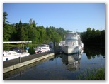
Chaffeys
 Going
up we just skipped right through Davis, Chaffeys, and Newboro. Coming back
we knew better and spent at least 2 nights at each. I guess our favorite
was Chaffeys. While there was lots of activity there it was such a friendly
place and the folks were having such fun that we really enjoyed it. Besides,
we had 30 amp power and I could connect to a good wifi signal. The weather
was great and the scenery couldn't be better.
Going
up we just skipped right through Davis, Chaffeys, and Newboro. Coming back
we knew better and spent at least 2 nights at each. I guess our favorite
was Chaffeys. While there was lots of activity there it was such a friendly
place and the folks were having such fun that we really enjoyed it. Besides,
we had 30 amp power and I could connect to a good wifi signal. The weather
was great and the scenery couldn't be better.
Newboro
 Again,
I had 30 amp power and could connect to a good wifi signal. The little
town is cool and they have a great ice-cream store :-).
Again,
I had 30 amp power and could connect to a good wifi signal. The little
town is cool and they have a great ice-cream store :-).
(For us) The Upper Portion
We had originally planned to go al the way up to Ottawa and back on Letitia.
After listening to several local boaters we decided to only take her as
far as Merrickville and do our Ottawa sightseeing by car. We were pleased
with that decision.
Smiths Falls is about halfway between Kingston and Ottawa - about 60
miles. give is another 15 to Merrickville and our total miles traveled
are about 150 miles. We only took 33 days to do then!! Next time
we won't travel as fast.. |
 |
Poonamalie
 There
are power outlets above the lock. While it is only 2 miles by water and
3 by car from Smiths Falls, it seems like a different world. We spent altogether
4 nights here and might have spent more if they had let us. The Canal rules
say 2 nights but many locktenders take a look at the traffic and relax
the rule somewhat. It is real close to our favorite spot.
There
are power outlets above the lock. While it is only 2 miles by water and
3 by car from Smiths Falls, it seems like a different world. We spent altogether
4 nights here and might have spent more if they had let us. The Canal rules
say 2 nights but many locktenders take a look at the traffic and relax
the rule somewhat. It is real close to our favorite spot.
Smiths
Falls
 Boats can dock at both the Canal lock walls (no power) and at the Victoria
Park Campground (run by the Chamber of Commerce). The campground is half
price if you have a Canal docking pass and they have power for $5 per night.
Wifi is available for free (the park was having challenges but ...). Smiths
Falls is a good sized town and the Beer Store, LCBO, and grocery stores
are all within four blocks of the waterway.
Boats can dock at both the Canal lock walls (no power) and at the Victoria
Park Campground (run by the Chamber of Commerce). The campground is half
price if you have a Canal docking pass and they have power for $5 per night.
Wifi is available for free (the park was having challenges but ...). Smiths
Falls is a good sized town and the Beer Store, LCBO, and grocery stores
are all within four blocks of the waterway.
Merrickville
 We
didn't go through the locks (4 steps) but rather tied up to a free dock
in 'The Pool', the impoundment above the dam. Wifi was available at the
Library and a few other places in town. Town was fun and people watching
was ample.
We
didn't go through the locks (4 steps) but rather tied up to a free dock
in 'The Pool', the impoundment above the dam. Wifi was available at the
Library and a few other places in town. Town was fun and people watching
was ample.
We had a grand time. The Rideau is different from the Trent-Severn,
I think in part because the Rideau felt much more intimate.
We plan to get back and spend much more time there.
I have included some links that you might find interesting about the
Canal.
Google 'Rideau Canal' for more
Pat's Rideau Waterway Cruising
Guide
and
The Rideau Canal Welcome
Page
Till Later!!
The Captain and Mary
August-September 2009