I will continue to search for current measurements but in the meantime here is what we experienced.
The current is also a function of the amount of water in the river. After seeing what 'normal' flow amounts to, I expect I will be as interested in correlations between higher water and higher flows.
Depth
I worried a lot about this because of the number of stops we had to
make.
The question in the Fall was "With the low water in the river, will
I have problems anchoring out of the way of the tows"?
In the Spring it was "With the added time of transit because of the
adverse current, will I have problems anchoring out of the way of the tows"?
While there are numerous locations on the Mississippi where the Corps of Engineers measure the height of the river, I am going to use the gage at Cape Girardeau as an indicator of what is happening. I am also choosing here because this is one of the few (and the best) places to anchor off the river and the height of the river relative to the measuring device (the Gage) will say something about whether you can anchor in the Little River Diversion Canal or not.
The 'River Stage' does not measure the depth of the river. It measures
the height (+ or -) of the river relative to the zero point on the Gage
which the Corps uses. However, I do have a couple of data points that for
me relate the stage with the depth of water in the Diversion Canal.
|
|

This chart depicts the August, September, and October river stages for
the last 4 years. I haven't looked real closely at lots of years but I
suspect they will vary considerably. Also note that a 10' swing in a week
is not unusual at all.

Contrast the Fall water levels with the Feb, March, and April levels.
(note the change in vertical scale) It becomes very clear why you
have to pick your times carefully going up the river against the current
in the Spring.
. 
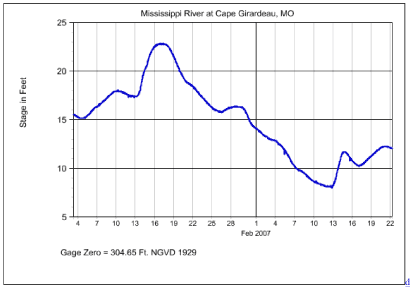
I didn't include 2007 in the plots so here is what happen from January
4 - Feb. 22. To see current data click this link - Year-to-Date
River Stage for Cape Girardeau.
| []Some background:
We had come down the Mississippi in the Fall of 2005 at close to the completion of the loop. We left the boat, a Gulfstar 44 Motor Cruiser - a full displacement boat with a top speed of ~9.2 mph, on Pickwick Lake for that winter. Since we had enjoyed Lake Michigan so much coming down we decided to cruise the Tennessee River and then head back up the Mississippi toward the Lake and winter there for the next winter. I have our multi-year journey chronicled on our web page www.loopcruiser.com. The 2005 set looks at the trip down and the 2006 set looks at the trip up. I spent lots of time that winter worrying about what we would find going back up stream and searching for information. We cut short our early season cruising somewhat (we had planned going up the Cumberland as well as the Tenn) because of anticipated weather and went back up in June of 2006. []Chronicles:
The best estimator of river current I can find is 'River Stage', the water height above some rather arbitary point which is different for every place it gets recorded. You might want to take the time to look over http://www.loopcruiser.com/cruise/Mississippi/Water&Current.html now. The graphs were generated from the Corp data pointed to below.
[]Data Sources
Daily stage values www.RiverGages.com - choose St. Louis district and Mississippi Basin Also http://mvs-wc.mvs.usace.army.mil/dresriv.html (I would look at this almost daily during prep period) []Observations: The river begins to rise toward the end of March and seems highest
in May.
Counclusions:
If the river stage at Cape Girardeau was less than 15-18 feet I wouldn't hesitate to go and I would expect currents in the 3-4 mph range. If the stage were greater than ~23-25 feet I would expect 4-5 mph and if much higher would wait till they came down. There are places to anchor other than the ones pictured on my page. I'll reserve that topic for another time. The only real stretch to worry about is the 70 miles from C.G. to Kaskaskia L/D. I suspect your boat speed is much like mine so that will really be a long haul if the current is more than about 4mph. Notice that if you use these stops you only have to anchor one time in a River around Cario, Il and the Ohio may be preferable to the Mississippi. Let ne know if there is anything else I can help you with. At the right time of year the trip UP can be great fun. HTH
|
elliott bray feb. 22, 2007