Adventures (and Misadventures) of Elliott and Mary
Issue 6 - May 24, 2004
Up the East Coast to the End of the Atlantic ICWW…
We left you, dear reader, poised to journey into the Georgia lowlands.
We went there. We also motored through the South Carolina and North Carolina
coastal waterways. For technical reasons I will not talk about, you will
have to close your eyes and imagine many of the sights we saw. :(
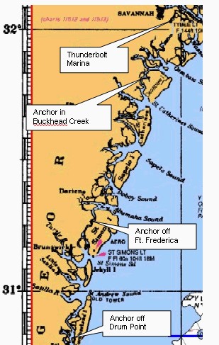
I will provide you with some 'chartlets' to give you a spatial reference.
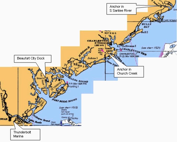 The
next two stops were marinas.
Thunderbolt, GA is just below Savannah. We needed to stop and get a
prescription filled at the local Eckerds. We rode our bikes into town and
the nicest pharmacist did all the coordination between the Slidell doctor's
office, the Slidell Eckerds, and her parmacy in Thunderbolt. That could
have been a disasterousexperience butshe made it possible for us at Thunderbolt.
If you will look again at the chart, you can see that the Atlantic is
just right there. It flows in and out those inlets with dependable regularity
and real force. This became really obvious at our next stop.
We stopped at the Beaufort (pronounced Bew-fort), SC city dock for a
pumpout and a night ashore. We borrowed the courtesy car for a trip to
town for groceries and a look around. We were docked at one end of the
City dock on the river side. The current sweeping past the long 'face'
dock (one you tie alongside of) was something else!!
Parts of town were right along the river and we unpacked the bicycles
for a tour. I am sorry I don't have the pictures of the town. The neighborhood
was impressive, moss hung oaks shading equally impressive 1800's homes.
I wondered how Sherman missed them.
Let me point you to the chart again. The ICW in this stretch of the Georgia/SC
lowlands winds up creeks and then through short cuts to the next creek
where it goes down to a river and then down to a Sound and back up a river
and then across ... You get the picture. Sometimes the current gives
you a push, sometimes the opposite. Part of the trick is that you don't
want to be going the wrong way in small narrow passages. That's where the
current really gets fierce. In part this attention to current flow determined
our stop in Church Creek south of Charleston. We choose to go past the
city for this trip and wanted to get across Charleston harbor while the
tide was slack.
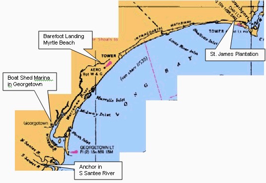 We
went into Georgetown SC for two nights and a little R&R. This was also
a mail stop. Georgetown reminded me of New England - southern style. There
were many, many houses dating from the late 1700's to early 1800's, all
being currently lived in and cared for. The town wasn't large and whether
the steel mill would open again was big news but we want to visit again
by car sometime.
Picture this!
Its 'Bike Week' in Myrtle Beach, Barefoot Landing is a BIG shopping
mall which hosts biker vendor and display areas, and part of the facilities
includes a LONG, FREE dock on the ICW. Actually, the free dock and the
mall outweighed the biker attraction in our determination to stop for the
night. It was a sight.
We had been worrying about the next leg for the past week. One of the
inlets, Lockwood Folly, has been reported to have silted in and at various
times reportedly closed the ICW as a result. Since the tide there is 4.5
feet (and we draw 4-4.5) we didn't foresee particular problems as long
as we could find the channel but high tide only occurs twice a day and
there were scheduling challanges. There is a pontoon bridge about two hours
earlier in the journey (it floats on a barge in the water - the only one
left on the ICW) that only opens on the hour and, reportedly, not at all
at low tide . We had to make the bridge at the right time.
However, we made it through, thanks to a bigger boat that had been forced
back and, while waiting for more water, was helping direct boats as to
the proper course. I do have to give a negative assist to a little fisherman
who insisted on fishing at the exact spot I need to get to for the next
turn.
We will leave you for now with us safe and securely docked at the St.
James Plantation Marina just short of Cape Fear. We have traversed the
shoals and need to be at the right place at the right time for the tide
on the river as it flows up toward Wilmington, NC.
We will have about a week left to go before Portsmouth with a
couple of hard days ahead. We have two more days of coastal waters to do
and then we head north across the Neuse River, the Albemarle Sound, and
through the Dismal Swamp.
That will be issue #7.
Will be back in to touch soon.
The Captain and Mary
May 24, 2004
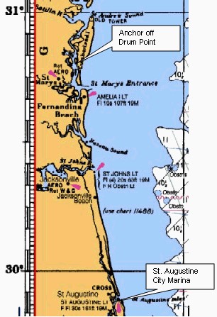

 The
next two stops were marinas.
 We
went into Georgetown SC for two nights and a little R&R. This was also
a mail stop. Georgetown reminded me of New England - southern style. There
were many, many houses dating from the late 1700's to early 1800's, all
being currently lived in and cared for. The town wasn't large and whether
the steel mill would open again was big news but we want to visit again
by car sometime.