Adventures (and Misadventures) of Elliott and Mary
Issue 16 - August 2005: Across the top of Lake Huron - Georgian Bay and
the North Channel
Out of the Canals
The North Channel and Georgian Bay are the top parts of Lake Huron. This
is where the 'rubber meets the road', or in this case, where the water
meets the rock.
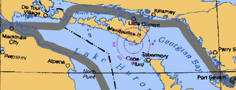
Georgian Bay
We rested for a couple of days in Port Severn and them went through the
last lock on the Trent-Severn down to Georgian Bay. From there southwest
to Pentang Harbor and town of Penetanguishene. Mary and Letitia were here
for four days while I made a trip to Boise Id. After finishing out our
week we headed north for O'Donnell Pt. and our entrance into the
small boat channel up the coast of Georgian Bay.
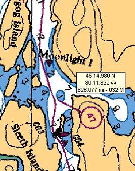
Travel on the small boat channel is not quite like cruising up the Hudson.
An example, miles 45-47 coming out of Port Severn.

There are more open stretches but it's hard to concentrate and enjoy
the scenery at the same time.
 The charts
and reality come close but don't quite tell the full story (nor does a
small picture). The trees and the sky and the water and the ... all
were spectacular. The charts
and reality come close but don't quite tell the full story (nor does a
small picture). The trees and the sky and the water and the ... all
were spectacular.
Reading distances off the charts wasn't as easy as I would like sometimes.
Note how far apart the red and green marks in the center are apart. (NOT!)
The chartlet for this area is to the right. |
 |
Scattered all along our journey were summer cottages, most accessible
only by boat.

North Channel
Here are some of the places I would like to show you pictures of.
-
Killarney at the juncture of Georgian Bay and the North Channel
-
Little Current with its narrow pass which funnels wind driven water
between two pieces of the North Channel
-
Blind River up on the northern edge - the jumping off port for the 45 mile
crossing to Drummond Island and the USA
and
-
Covered Portage Bay where we anchored for three days.
The water was incredible
The sky was blue
We sat through a front with 45-50 mph winds in complete comfort
-
Anchor Island where we anchored, the Benjamin's, John and Smith Islands,
... where we didn't
But, in a repeat of an event a year ago, the technique used to download
this camera load was faulty. i.e. I screwed up and lost them.
The chart, your imagination, and our memories will have to do.

Back to the USA
We cleared Customs at Drummond Island. We had shot records for the cats,
passports, probably ever dental records. They wanted my name, Canadian
Customs number, and Letitia's documentation number. We were ready
though...
We took out at 7:15 the next morning.

We passed through DeTour Pass on our way from the Drummond Island and
headed west. We motored around Mackinac Island to the north and docked
just short of the bridge across the Mackinac Straits at the St. Ignace,
Michigan, municipal marina. I thought the water in some parts on
Canada was clear!! You could see the bottom 20 feet down as clear as a
bell.
Down the Michigan coast next issue.
Till Later!!
The Captain and Mary
September, 2005